
The other option - heading up Coburn Creek
The decision may have seemed nuts, but it's not like I was heading up Coburn Creek blindly. Based on the topo map, (despite the fact they are dated) it clearly showed water flowing down from the lake to where we were. There was a big marsh midway, of which I couldn't be certain whether it had closed in after all these years, but I figured it couldn't be as bad as the ATV trails. I hoped. If it was, I knew it would definitely be more exciting than trudging down a dusty trail. More importantly, the water levels were up from last year, so I figured the chances would be better than ever to make this attempt to Coburn Lake.

Coburn Marsh was actually easy to get through
I couldn't ignore the questions or feelings of doubt as we set out. Especially since Anita was making sarcastic remarks of how I always get us into interesting dilemmas. I figured as a back up, if worse comes to worse, we could just head back the way we came. When the waterway quickly narrowed and resulted in us man-handling the canoe, my doubt started to grow in earnest, but we eventually got to a beaver dam that thankfully gave us a platform to paddle again. I was then relieved when we surprisingly got through the marsh fairly easy. Well, that is until we accidentally took a wrong turn.
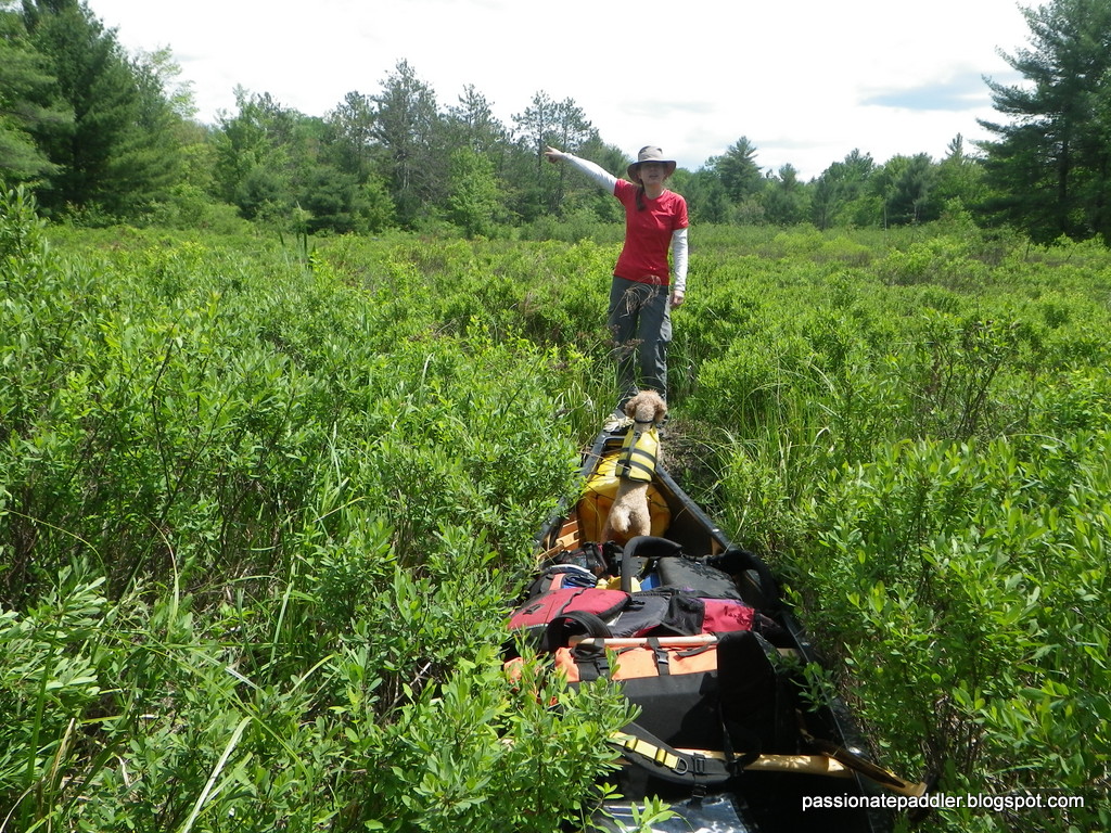
Which way? Her guess was as good as mine, but in the
end, it was wrong either way.
What we thought was a deeper wider channel, slowly narrowed and saw us squished tight between alders. We obviously couldn't paddle any more, and had to resort to balancing on tenuous mats of bog as we dragged the canoe through. It was soon obvious that things were going from challenging to out right ridiculous. We couldn't even see where we were heading due to the dense vegetation, or where we may end up. Out came the GPS, and not surprising, it told us we were definitely going the wrong way. So back we went, hauling the canoe backwards, occasionally dropping deep into the abysmal black swamp waters. We then headed up the correct channel, despite being shallow and having logs strewn across it, and ended up at the base of a small set of rapids. From here, we bushwhacked approx 150m and were ecstatic to emerge from the forest to witness the gorgeous blue waters of Coburn Lake. We made it! The plan paid off and we were thrilled to have finally arrived at this elusive lake. Not everyone would agree to my route choice, but despite the few struggles, I enjoyed this route much better than slogging down an ATV trail.

As you can clearly see, THIS was the right way!
This roundabout way to get to Clear Lake was totally worth it. Coburn and Little Coburn Lake is gorgeous, and I'm so glad I passed through this way to see them. I can't wait to come back to this area and spend more time here, but for now, we continued on to Clear Lake. Locating this portage also took a bit of time, as we assumed the trail was further in the marsh, but had to back track and found it was another ATV trail at the north end of the lake. Once on Clear Lake, the skies overhead started to darken as big clouds moved in. As it was also late in the day, and the route to Scrabble Lake from the marsh north of us was not a recommended route, (Guess which way we are going?) I thought it was wise to call it quits for the day, especially since I put Anita through enough for one day. We made camp on the big island in the middle of Clear Lake.

We finally made it to Coburn Lake. What a relief!
The next morning, we headed straight for the marsh - yet again. Since we already had information on the difficulty of getting through this way, I was hoping the elevated water levels would somewhat make it easier. Of course we could have gone the more typical way of portaging out of Clear Lake on the west side, but what fun is that? Besides, the route through the marsh seemed the most logical way to get to Scrabble Lake (assuming it was passable) and I was determined to find it. We were soon privy to the difficulties that lay ahead. First off, there were the generous placement of slippery logs beneath the shallow dark waters that made for some tough liftovers. The beaver dam that appeared gave us some hope, but that quickly faded as the alders choked us out. Despite pushing down several leads, they all closed in tightly, and with it, signs of water. I was literally at the brink of defeat.

Storm clouds and rain moving our way on Clear Lake. And
yes, there was a rainbow before the rain hit us!
yes, there was a rainbow before the rain hit us!
I could see the ridge in the not-too-far distance and knew getting there was the key to Scrabble Lake. I even considered portaging, but I knew trying to navigate through the alder filled marsh with floating bog mats would be both challenging and a scary proposition, especially as my wife has a fear of falling into a bottomless bog. (Don't we all?!) One look at her face was all it took to know that that proposition was off the table. Out of options and frustrated, I decided to make one last push, barring this, we would turn back. I decided to head closer to the east shoreline (despite the lack of water) and figured if we couldn't make progress through the marsh, we could always portage along it. Anita was on board, and away we went.

Heading into the marsh to search for the elusive
passage to Scrabble Lake
Hauling and dragging the canoe back and forth was a lot of work. However, I think Teddy, our poodle, was working just as hard trying to keep on all four legs. The harsh rocking motion, including pitching from front to back or side to side, ultimately challenged his sense of balance. Also, Anita's fear of the bog extended to Teddy, which meant he was totally forbidden from jumping out of canoe, despite wanting to escape the portable earthquake machine. It was then no surprise, when he ventured too close to the gunwale one time, he found himself unceremoniously dumped in the murky waters. A mother's instinct is a powerful thing. I never saw Anita move so fast, as she pulled him out before I could say anything. I sometimes wonder what would happen if I fell in? Hmmmmm?

Out of the shadows and into the light - of Scrabble Lake
Mission accomplished
We pushed on slowly, making progress canoe length by canoe length. Unexpectedly, it actually got better as the vegetation parted and more water appeared. In fact, we even got to paddle briefly, until we came to a high beaver dam. That would explain the low water levels on our side, but it seemed promising up top. The big liftover brought us up to another marsh. From here, we thought we would have to paddle through it, as it exits out as the east end of Scrabble Lake, but we didn't. Looking north, we could clearly see a narrow channel of water extending out to what looked to be open water. We couldn't believe our luck and checked the map to confirm what we were seeing. A short paddle through the shallow waterway had us basking in the sun and blue waters of Scrabble Lake. Success!

The views along the way to Scrabble Mountain were better
than the one at the summit. Go figure!
That day was a short one, to reward us for our hard work getting to Scrabble Lake. We found a prime campsite on a island on the NE side of the lake and quickly set up camp. The only other calorie burning activity we took part in, was hiking up to the peak of Scrabble Mountain, also the highest point on the Ganaraska Trail. The walk up had some scenic lookouts along the way, but surprisingly, the summit was a bit of a let down. Other than a cairn/memorial to mark the highest point, the view was all but blocked by the surrounding trees. Instead of being wowed by a panoramic vista of the area, we instead took shelter in the shade to get away from the intense heat and rehydrate ourselves. After our break and a few cursory snapshots to say we were there, we headed back down to our cozy island campsite.

Our nice island campsite where I hatched the
plans for the next day.
This island site was a great way to end the day, where I went for a nice swim to cool down and Anita got to relax and read her Kobo. As the sun began to set and I pulled out the map to look over our route for the next day, I had a eureka moment. I put on my best smile and called Anita over. She already knew something was up, as she could read my face. She saw through me and sarcastically said, "Now what?" I told her I had a brilliant idea and found another possible route back down to Fishog Lake through Digby Creek. She soon realized on the map that more than half of my intended route had not been travelled by anyone before. Yup, she gave me the look alright!
Yes, I do believe there is a Part 3!
tPP


