Wednesday, December 11, 2013

Finally Back!

It's always sad to see the season end, but it is a good time to
look back, reflect, and chart the course
of next year's trips!

Wow, it's been awhile since my last post! It's been quite a busy tripping year and the little time I had at home, was put to use doing house stuff. You know, the stuff that never gets done if you are away too frequently on canoe trips? More like, stuff that if you don't get done, you WON'T be allowed to go on canoe trips! Well, the paddling season has definitely wound down and I'll (reluctantly) be spending more time indoors. It is now time to reflect, go through thousands of photos and spend some time writing. There are a few reviews I'll be doing this year, plus the usual collection of odd, crazy, and funny stories that happened to me (and those that were with me) during my trips.

Hope you all had an amazing and safe paddling season this year. The weather was a bit wonky this year, but then again, when isn't it? Anyhow, it's good to be back. Time to pack on some 'winter fat' and ride out the snow cover. 

As a Game of Thrones fan, if you are aware of the House Stark's motto, it really is true. "Winter IS Coming".

Cheers,
tPP

Thursday, August 1, 2013

Revisiting the Queen - Part 3

Maybe because of the success we had the past couple of days, or the thrill and excitement of discovering new routes, either way, I wanted more. I couldn't deny that some of the nice scenery along the way came with a disproportionate amount of effort, but we all know, you don't get something for nothing. As long as you are working within your limits and know when to give and take, it can make for an exciting adventure!

Heading out of Scrabble Lake to begin yet
 another day of adventure!

 After our well rested stay on Scrabble Lake, we headed out the next morning towards the SW end. Here we entered a narrow arm where we were to find a portage to another marsh. Sense a theme? As usual, it wasn't obvious. We could hear water rushing down from the elevated level where we were at, and found it was a creek that presumably flushed into the marsh somewhere below. The north end of the creek didn't show any promise or signs of use, so we checked out the south side. It was here that I was able to discern what looked to be a trail, as it opened up and eventually led to the marsh below. Backtracking, we found the overgrown 'opening', and of course a pink tape that was well covered by leaves. Before beginning the short portage, I cleared the take-out and added more pink tape for future paddlers.

Some trail maintenance and new signage
for subsequent paddlers.

 Starting the paddle through what looked to be a big marsh on the topo had me wondering about the conditions we were going to find. Unexpectedly, it was actually easy to paddle through, with areas that were even open. Other than the odd beaver dam here and there we had to liftover, it was a nice paddle through what felt like a very remote and isolated area. We also passed the point where the portage from Clear Lake was to come into the marsh, but we never saw any signs of it, as it was probably overgrown as well. We were making good time, so we also decided to detour west to see Cranberry Lake. Exiting the marsh, we entered a creek which we paddled upstream as far as we could, where it got shallow and rocky in a narrow gorge. From there, I just portaged the canoe along the creek bed before we jumped in the canoe for a short paddle to see the lake. Assuming we would find it devoid of human presence, like a long lost lake, we were sorely disappointed to find a hunting cabin just north of the creek. I guess other people had the same idea too!

Portaging along logs to Cranberry Lake

 We soon left the scenic lake with the thought of coming back in the future to explore further. Once back in the marsh, we continued south through a verdant pool of plate-sized lily pads. Looking ahead, I could see the shoreline close in and I started to get that nagging hint of concern. Would we be able to get through? With relief, we actually were able to, but it definitely took more effort. It was not for the lack of water, but because of the many logs strewn across the narrow waterway. I'm sure Teddy wasn't enjoying all the liftovers, considering he had to stay put in the canoe. We were just thankful he didn't need Gravol. Doing liftovers across beavers dams is one thing, but try doing it on half submerged logs, floating logs, or ones that felt like they were slick with oil. It took some steady balance and quite often a wet foot, but we were having fun and laughing along the way. We were counting on each other to fall in first. Luckily, neither one of us ever did.

One of many floating logs we had to lift over. 
Thankfully, this one was fairly big!

 We eventually arrived in the vicinity west of Red Boat Lake. Apparently, there is a portage that can get you into that lake if you continue paddling west, but we weren't headed that way. From here, we wanted to continue south to the unnamed pond before Fishog Lake. Problem was, there was no recorded or documented case of anyone going this way. Like Colburn Creek, we were going in blind. We could evidently see the way ahead was a dead end. The water ran out, and there was thick wall of alders blocking the way. Looking at the topo, we headed to the small island beside us, that marked the entrance to another marsh that leads west to Red Boat Lake. We took a lunch break on the island while I checked and rechecked the route I was going to take us on. It was a last minute do or die feasibility study. Good thing it wasn't up for discussion or a vote. With only my wife and I, we would always be at an impasse!

Lunch break on an island surrounded by
a thick rich marshland

 The main issue was whether we could continue south. The east side of the island was obviously not an option, so we decided to check the west side and then determine whether to go for it. Paddling over, the other side definitely looked promising, as we could see the water wend it's way south, despite being shallow and log ridden. But first, we had to manage a liftover across multiple floating logs. Of course with Anita in the front, she had to get out first. The first step was fine, the second? Well, this incident was the closest I came to winning the bet. Her leg immediately sunk with the log halfway up her thigh! What surprised me more was how fast she was able to swing her leg up and onto the canoe gunwale! I couldn't stop laughing while bracing the canoe the other way to prevent her from taking Teddy and I in! It's amazing what fear can do to people. See, didn't I tell you she has a fear of the bottomless bog? We did finally make it over, but I was subjected to a thick layer of sarcastic remarks as we continued on. I couldn't get the grin off my face!

Hmmm, the canoe just ain't going to make it
under. Oh well, liftover it is!

 We eventually came upon an ATV bridge, which I surmised could be a good back-out option in case we got stuck, however, it kind of disrupted the sense of unaltered wilderness I was enjoying. As the bridge was too low to paddle under, we had to lift over it. I remarked how awful the footing on the bridge was compared to logs; I got a look, then a punch. A short paddle brought us to another narrowing, although this time, we could definitely hear the sound of rushing water. We pulled out at a small beaver dam before the drop, as I got out to inspect what lay ahead. I could see the water cascading several times through a rocky gorge, as it flushed out into an open valley, which was just spectacular. I couldn't believe how beautiful the area was. I rushed back and relayed my findings to Anita, as we then bushwhacked ahead to the foot of the small falls. On our way back, we did some trail maintenance and put up some flagging tape for future paddlers that decide to pass this way. One curious thing to note, there actually did seem to be a slight trail. Whether it was an animal trail, or a trail once travelled by natives in this area, it was hard to discern. But based on the depression and characteristics of the ground, someone, or something once passed this way many years ago - interesting. 

Discovering a small set of  falls along the way 
and the scenic landscape around it.

 We took some time to admire the splendid scenery before slowly paddling away. If I knew what we were going to face ahead, I would have definitely opted to camp at the falls, but since we didn't, we had to continue on. A short paddle brought us to another drop in elevation, where as before, we bushwhacked around the cascading rapid. Clearing the brush as we went, we again found evidence of a faint trail. I was now certain, we weren't the only ones that came through this way. The big question was who? Back in the canoe, we continued on down a narrow corridor, where we could see the shoreline and trees close in. The landscape was changing.

Passing a huge erratic along the lower 
section  of Digby Creek. 

 Stopping at a beaver dam that had a significant drop, we could see the vale we were entering. Leaving the open boggy marsh, there was now rocks in the creek bed, huge erratics along the shore, a canopy of trees atop our heads, and even current coursing through the water. Before continuing on down the creek, we had to consider a contour line on the topo that crossed the creek further down, most likely indicating a falls. We needed to decide now what we were committing ourselves to before moving on. Portaging would be a challenge as the shoreline abruptly rose up on either side. Looking down as far as I could, noting the shallow creek, as water danced deftly around all the rocks, we figured we'd go for it. We couldn't paddle anyhow, so we figured it would be safe since it would be slow drag through the creek until we came to the drop, assuming it was going to be like this the whole way.

Opting to drag the canoe along this section was
 both enjoyable and scenic.

 Despite dragging, it wasn't all too strenuous. It was cool under the canopy due to all the shade, and the slick Twintex material slipped easily atop the rocks. Other than a rocky ledge, which we got down fine after man-handling a log that blocked the way, it was pretty straight forward travel. Surprisingly, we even got to paddle a bit when the creek deepened. It was very pretty and intimate in this section, and we were thoroughly enjoying the decision to drag through, rather than find a way in the bush. Soon enough, we heard the distinct roar of angry water. We pulled out well before the drop and I scouted ahead along the shore. It was a drop alright, but not straight down. It had a good pitch where the water cascaded down, but not enough to stop us from taking the canoe down carefully. After deciding which line to take, we cautiously guided the canoe to the bottom. At the base, it made almost an abrupt 90 degree turn, where we dragged the canoe over rocks to deeper water. Paddling out to open water, we could see the the steep portage that made quite an impression on Anita on our way in. This was it, we finally made it to our intended destination intact!

At the top of the falls, waiting for a hand to
guide the canoe down.

 We spent our last night back out on Fishog Lake before heading out the next day. The end of the trip almost seemed docile, but the morning we left, it gave us unforgettable farewell, as the skies dumped on us like crazy. It was a poignant reminder before we left, that despite being on familiar waters now, we were still in the wilds of Queen Elizabeth 2 Wildlands Park.
 tPP 

Back on the all familiar Fishog Lake, 
we could now relax!

Post Trip Notes: This is the first time owning/having a GPS on a trip. As you can see, it came in quite handy. I've never been a fan of having electronic gadgets on trips, preferring to use my God-given talent, (aka my brains), but I can see the merit. When we got lost on this trip, it may have taken more time and effort, but I would have certainly still figured it out - like many times before. However, there is value in the device - such as pinpointing important landmarks, marking new portages, or even new routes that can be corroborated and added to a map database. I'm still new to the whole thing, and need to spend more time with it to get familiar with its features. However, with the information I have from this trip, I plan to share it with Brad Jennings (explorethebackcountry.com) so that he can add it to his already detailed map of the park. Now, you have no excuse not to follow in our wake! Have fun!

Thursday, July 11, 2013

Revisiting the Queen - Part 2

The other option - heading up Coburn Creek

The decision may have seemed nuts, but it's not like I was heading up Coburn Creek blindly. Based on the topo map, (despite the fact they are dated) it clearly showed water flowing down from the lake to where we were. There was a big marsh midway, of which I couldn't be certain whether it had closed in after all these years, but I figured it couldn't be as bad as the ATV trails. I hoped. If it was, I knew it would definitely be more exciting than trudging down a dusty trail. More importantly, the water levels were up from last year, so I figured the chances would be better than ever to make this attempt to Coburn Lake.

Coburn Marsh was actually easy to get through

I couldn't ignore the questions or feelings of doubt as we set out. Especially since Anita was making sarcastic remarks of how I always get us into interesting dilemmas. I figured as a back up, if worse comes to worse, we could just head back the way we came. When the waterway quickly narrowed and resulted in us man-handling the canoe, my doubt started to grow in earnest, but we eventually got to a beaver dam that thankfully gave us a platform to paddle again. I was then relieved when we surprisingly got through the marsh  fairly easy. Well, that is until we accidentally took a wrong turn. 

Which way? Her guess was as good as mine, but in the
end, it was wrong either way.

What we thought was a deeper wider channel, slowly narrowed and saw us squished tight between alders. We obviously couldn't paddle any more, and had to resort to balancing on tenuous mats of bog as we dragged the canoe through. It was soon obvious that things were going from challenging to out right ridiculous. We couldn't even see where we were heading due to the dense vegetation, or where we may end up. Out came the GPS, and not surprising, it told us we were definitely going the wrong way. So back we went, hauling the canoe backwards, occasionally dropping deep into the abysmal black swamp waters. We then headed up the correct channel, despite being shallow and having logs strewn across it, and ended up at the base of a small set of rapids. From here, we bushwhacked approx 150m and were ecstatic to emerge from the forest to witness the gorgeous blue waters of Coburn Lake. We made it! The plan paid off and we were thrilled to have finally arrived at this elusive lake. Not everyone would agree to my route choice, but despite the few struggles, I enjoyed this route much better than slogging down an ATV trail.

As you can clearly see, THIS was the right way!

This roundabout way to get to Clear Lake was totally worth it. Coburn and Little Coburn Lake is gorgeous, and I'm so glad I passed through this way to see them. I can't wait to come back to this area and spend more time here, but for now, we continued on to Clear Lake. Locating this portage also took a bit of time, as we assumed the trail was further in the marsh, but had to back track and found it was another ATV trail at the north end of the lake. Once on Clear Lake, the skies overhead started to darken as big clouds moved in. As it was also late in the day, and the route to Scrabble Lake from the marsh north of us was not a recommended route, (Guess which way we are going?) I thought it was wise to call it quits for the day, especially since I put Anita through enough for one day. We made camp on the big island in the middle of Clear Lake.

We finally made it to Coburn Lake. What a relief!

The next morning, we headed straight for the marsh - yet again. Since we already had information on the difficulty of getting through this way, I was hoping the elevated water levels would somewhat make it easier. Of course we could have gone the more typical way of portaging out of Clear Lake on the west side, but what fun is that? Besides, the route through the marsh seemed the most logical way to get to Scrabble Lake (assuming it was passable) and I was determined to find it. We were soon privy to the difficulties that lay ahead. First off, there were the generous placement of slippery logs beneath the shallow dark waters that made for some tough liftovers. The beaver dam that appeared gave us some hope, but that quickly faded as the alders choked us out. Despite pushing down several leads, they all closed in tightly, and with it, signs of water. I was literally at the brink of defeat. 

Storm clouds and rain moving our way on Clear Lake. And
yes, there was a rainbow before the rain hit us!

I could see the ridge in the not-too-far distance and knew getting there was the key to Scrabble Lake. I even considered portaging, but I knew trying to navigate through the alder filled marsh with floating bog mats would be both challenging and a scary proposition, especially as my wife has a fear of falling into a bottomless bog. (Don't we all?!) One look at her face was all it took to know that that proposition was off the table. Out of options and frustrated, I decided to make one last push, barring this, we would turn back. I decided to head closer to the east shoreline (despite the lack of water) and figured if we couldn't make progress through the marsh, we could always portage along it. Anita was on board, and away we went.

Heading into the marsh to search for the elusive
 passage to Scrabble Lake

Hauling and dragging the canoe back and forth was a lot of work. However, I think Teddy, our poodle, was working just as hard trying to keep on all four legs. The harsh rocking motion, including pitching from front to back or side to side, ultimately challenged his sense of balance. Also, Anita's fear of the bog extended to Teddy, which meant he was totally forbidden from jumping out of canoe, despite wanting to escape the portable earthquake machine. It was then no surprise, when he ventured too close to the gunwale one time, he found himself unceremoniously dumped in the murky waters. A mother's instinct is a powerful thing. I never saw Anita move so fast, as she pulled him out before I could say anything. I sometimes wonder what would happen if I fell in? Hmmmmm?

Out of the shadows and into the light  - of Scrabble Lake
Mission accomplished

We pushed on slowly, making progress canoe length by canoe length. Unexpectedly, it actually got better as the vegetation parted and more water appeared. In fact, we even got to paddle briefly, until we came to a high beaver dam. That would explain the low water levels on our side, but it seemed promising up top. The big liftover brought us up to another marsh. From here, we thought we would have to paddle through it, as it exits out as the east end of Scrabble Lake, but we didn't. Looking north, we could clearly see a narrow channel of water extending out to what looked to be open water. We couldn't believe our luck and checked the map to confirm what we were seeing. A short paddle through the shallow waterway had us basking in the sun and blue waters of Scrabble Lake. Success!

The views along the way to Scrabble Mountain were better
than the one at the summit. Go figure!

That day was a short one, to reward us for our hard work getting to Scrabble Lake. We found a prime campsite on a island on the NE side of the lake and quickly set up camp. The only other calorie burning activity we took part in, was hiking up to the peak of Scrabble Mountain, also the highest point on the Ganaraska Trail. The walk up had some scenic lookouts along the way, but surprisingly, the summit was a bit of a let down. Other than a cairn/memorial to mark the highest point, the view was all but blocked by the surrounding trees. Instead of being wowed by a panoramic vista of the area, we instead took shelter in the shade to get away from the intense heat and rehydrate ourselves. After our break and a few cursory snapshots to say we were there, we headed back down to our cozy island campsite.

Our nice island campsite where I hatched the
plans for the next day.

This island site was a great way to end the day, where I went for a nice swim to cool down and Anita got to relax and read her Kobo. As the sun began to set and I pulled out the map to look over our route for the next day, I had a eureka moment. I put on my best smile and called Anita over. She already knew something was up, as she could read my face. She saw through me and sarcastically said, "Now what?" I told her I had a brilliant idea and found another possible route back down to Fishog Lake through Digby Creek. She soon realized on the map that more than half of my intended route had not been travelled by anyone before. Yup, she gave me the look alright!

Yes, I do believe there is a Part 3!
tPP


Friday, June 28, 2013

What's New In 2013


Solid reputable outdoor gear from Sweden, period.

The paddling season is well under way and there is lots I would love to blog about, but time is elusive for me. It's amazing how little time I have between my job, work at home, and canoe trips. It was amusing one day, when an outdoor retailer I was discussing projects with, was surprised to find I actually had a full time job! Yup, I squeeze it all in - literally. It's great to get out on a lot of trips, but it actually is a lot of work. There is a lot of organizing, planning ahead and staying on top of things so you don't get too far behind. I also can't thank my wife enough for being a big part of all the preparations behind the scenes. It certainly helps to have a hand, as I certainly couldn't do it all without her. 

Teddy is thankful that he wasn't left out. As he now has
the gear, let's see if he has the desire! 

Okay, so I want to mention a few things before I get too far into the paddling season. Every year, I try to see what's new and different in terms of gear and use/test them during the current season. It not only helps with prospective buyers that are looking for information and advice on similar type gear, but it also helps me to discover the next best thing. So let's jump right in and see what's on the plate this year.

Traileader Jet, a Tech4O watch that is telling me that it is
going to rain. Yes, it forecast weather too!

From Eureka, I'll be testing out their new line of lightweight tents that are sporting some nice bright colours. They have 3 in this series, Amari, Midori, and the Taron, which I will be using this summer. Weight savings are always good, but let's see how they saved the weight, and how the tent stands up. I'll also be sporting one of their Tech4O watches, called the Traileader Jet, which is a brand/subsidiary under the Johnson Outdoors conglomerate. It is one of those fancy watches that pretty much tells you everything besides time - altimeter, barometer, compass, and thermometer. I opted for the one without the GPS, as I prefer a dedicated unit for trail finding.

Eureka has been making quality tents for years. Let's see 
what this new line of tents is all about!

I've also partnered up with the gang from the Canadian Outdoor Equipment Co. They have set me up with a bunch of gear to test and use, so look out for some reviews in the near future. They have some really cool high end gear, so I'm really excited to test them out. Some of their gear is from Europe, which are known to be solid reputable products, which unsurprisingly have been around for years. I will be using their line of Trangia stove/pot set, as well as the crème dela crème of axes - Gransfor Bruks axes. Not only is it a beauty to behold, but it just feels right. I can't wait to put this axe through its paces!

Crocodile Dundee once bragged about his intimidating knife.
Well here's an axe that has bragging rights too!

Hooligan Gear has been a solid partner of mine for many years, and this year, I will get to use their well regarded Rescue Throw Bags on our whitewater trips. The specs say it for themselves - paddled quick release belt, reflective tape, and Spectra rope. You don't fool around when it comes to whitewater, so the best gear, is the least you can do to help you along the way when needed. Also, Hooligan Hound gear couldn't have come at a better time, in supplying and helping us adjust my dog Teddy (and myself) to having him along on our canoe trips. Us human trippers are not the only ones that need good dependable gear. We are hoping to soon have Teddy become a Hooligan Hound!

It's reassuring to know you can count on quality
 safety gear, when you need it the most!

I have a weakness for wood, fire and stoves. Combined together, wood stoves. I have trialled several already, and now want to try another one out - the 180 Stove. Before I even had the chance to use it, I could tell by its design, I would love. Why, because this is how I would envision creating my own. It is one slick set up, but in operations and when compacted down. I'm totally stoked about using it and will obviously let you know how it performs. 180 Tack LLC, is an independent US based company in Colorado. 

A beautiful little wood stove, that I am really looking forward
to using. I just wished it stayed this shiny!

Last but not least, Jeff McMurtrie (of Jeff's Maps) and I have agreed to work together. We got a quick introduction, and then a great trip to start off our friendship and partnership this year. Who can deny the quality of maps that Jeff has put out to the paddling community, especially to all you avid Algonquin trippers. Now, the Killarney ones are soon to follow too! Not only do I hope to help him with info for his maps, (from my extensive tripping in many areas) but we have some projects planned for the near future too!

If you are an Algonquin tripping buff, look no
where else. This is THE map!

Okay phew! I think that's it for now. There is a few little odds and ends, but as you can see, that is more than enough stuff for me to use. I've gotten to a good start with trips this season and they will continue long into the year for me to try out all this gear. Excited as always to try new stuff, let's see how it all goes! Happy tripping everyone, and maybe you'll see me out there, figuring how to use some of this stuff!

A huge thanks to all my partners - and more importantly, new friends!

Cheers,
tPP

Sunday, June 23, 2013

Revisiting the Queen - Part 1

After my first canoe trip through Queen Elizabeth Wildlands 2 Provincial Park last year, I came back with mixed feelings. There was enough wilderness in the park that intrigued me, but all the float planes and cabins put a damper on the enthusiasm. Even the name of the park was bizarre, as I couldn't understand the correlation. Yet despite this, the lure to go back was nagging at me. I decided another trip was in order to satisfy my curiosity, especially since I didn't get to see the east side of the park.

Setting off on Head Lake to 
revisit QEW2 PP

Since my trip (and the subsequent blog post), Brad Jennings of explorethebackcountry.com sent me a nice email and we have since corresponded several times. Brad and his father Wayne have continued to map potential routes in the park and have generously shared that information with the paddling community. This is great for adventurous paddlers like myself, looking for new routes to explore - with the other bonus being that the park is close by. I know there are other paddlers, especially Jeff McColl that has helped Brad with this work. So with the same mindset, I hope to assist him where I can with any pertinent information that could be added to their already informative map.

Getting the flavour of the park last time around, I was well prepared to expect the same conditions, if not worse, since I also wanted to venture a bit off the known routes this time. Brad informed me before I left, that some of the route I was taking was better signed and cleared this time. After starting from a different access point this year, H1 (on Brad's map) we paddled east across Head Lake and made our way into to Fishog Lake for the first night. It was a short day as we left after work and we wanted to rest up for the route that lay ahead. Little did we know, the adventures that laid before us.

Enjoying the light show with the setting
sun on Fishog Lake

The next morning, we headed out of Fishog Lake in a northeasterly direction. We were to follow a chain of portages that would get us into Red Boat, then Coburn, and eventually into Scrabble Lake. Needless to say, it didn't really pan out that way. (Does it ever?) True to Brad's words, the signs were there, but being late spring and what seemed to be the lack of paddlers through this area, there was still a lot of growth. This often times hid the pink flagging tape that was to be our guide, so we took out our pruner (Yes, they work amazing for clearing trail!) and saw, and cleared/reflagged the trail along the way.

Evidence of Brad & Wayne Jennings work
in the park with the portage signs

One notable portage that took us out of a pond and into a narrow creek had Anita questioning the logic of its take out. Only being 290m, it was wasn't very long, but the start was straight up a boulder strewn incline. Brad mentions it in his map, but despite the forewarning, it requires stamina going up and deft footwork balancing over and around boulders. I took it as status quo, being familiar with this kind of portage, but Anita wasn't impressed. I guess it didn't help that she was hauling more than half her body weight on her back. In any case, as this area is rimmed in by high granite, there really wasn't any alternatives - yet.

Scrambling up the steep pitch of boulders

Travel-wise, on the water and off, it went fairly smoothly. Actual trail time took longer than usual, only because I was doing moderate trail maintenance and re-flagging as we went along. We had lunch on Red Boat Lake, before setting off on a 650m portage on ATV trails to Coburn Lake. It was supposed to be a straight forward carry; supposed to be. ATV trails are pretty evident, like how can you miss the furrows created from their big wheels? Also, we had to turn right at the Y-split, otherwise, we would end up on the 950m portage to Clear Lake. We started with hardly a second thought, as we knew exactly which way to go and and figured we would soon be on Coburn Lake.

Anita catching her breath at the top of the climb.
Can you tell she was thinking
happy thoughts?

I have to say, I hate following ATV trails. They don't go from point A to B in the most efficient way, much like an actual portage trail would. I don't want to go snaking from one side to the other, nor go up and down inclines, because I have a gas-powered engines to effortlessly get me there. I know at times, they do have to go around obstacles, but just like paddling through oxbows, you realize you just travelled double the distance. Not to begrudge the trail fun factor for ATV's, but do that with a pack and canoe on your back, it isn't fun. Give me the fastest point from one body of water to the next, without scaling Everest, much like how the First Nations people did it. Am I asking too much?

The Coburn Creek crossing - Teddy 
prefers shuttle service

Signage in terms of the faded pink survey tape was sparse at best. I think I saw maybe two strips? I'm sure Brad, nor anyone else bothered much with signage, as the ATV trails should have been somewhat self-explanatory. The little I did see gave me confidence we were going the right way, despite thinking we should have arrived at the lake by now. As Anita and I were doing one and a half carries, I sent her on ahead as I went back for the canoe. When I finally caught up with her, she was crossing a wide creek. At this point I knew for a fact, we were way beyond the 650m distance, if not double, but a wide creek crossing too? It was definitely still an ATV trail, with the purposeful rock placement in the creek. We put our stuff down after crossing and I pulled out the GPS that I was using for the first time. According to the map I printed, we actually do cross Coburn Creek. It seemed we were lower down based on the GPS, but because I had scribbled the approximate line of the portage on the topo map, I really couldn't be sure. It certainly seemed we were in the right place, but the distance travelled seemed awfully wrong.

Anita and Teddy recovering at the Coburn Creek crossing - 
this after our long fruitless march
 along ATV trails

You know when you get the feeling something is wrong, but some of the interpreted information is correct, you force the unknown to make sense? This not only makes you feel better, but makes the illogical, logical again. I now assumed the 650m distance was actually from the Y split, so the actual length of the portage was much longer. Ta-daaa! All fixed! So off we went, continuing along the ATV trail, thinking the lake would appear soon. I sensed we were heading in the wrong direction again, but the trail twisted and turned and soon had me flummoxed as to which direction we were actually headed. When again I was certain we were well passed the required distance, I pulled out my GPS and was shocked to find we were heading southeast, not north! Seeing my wife labour under the large pack as she came up yet another incline towards me, I thought I was going to be in BIG trouble.

Looking up Coburn Creek and optimistically
thinking THIS was the  key to getting
to Coburn Lake

Surprisingly, she was totally okay. After I took her pack off, and gave her water to drink, I explained the good news. I said with 110% confidence, that we were going the wrong way! She said she wasn't surprised. She sarcastically remarked that it was normal that I would take the longer and harder way around and laughed. (Phew! I thought I was going to become bear bait!) After a little break, we turned around and headed back to the Coburn Creek crossing. On the way back, with more than enough time to ruminate, I had devised the next plan of action. We would abandon the ATV trail and forge our own way to Coburn Lake - up Coburn Creek. Anita just shook her head.

Stay tuned for Part 2!


Wednesday, May 29, 2013

Measuring Up To Algonquinites

Absolutely gorgeous Hi-A-Wa-Tha Lake, who would have
known? A hidden gem inside Algonquin.

Most avid paddlers like myself, eagerly wait for the start to the paddling season when signs of spring abound. When the weather starts to warm and the daylight starts to lengthen, it is a sure sign that ice is melting too. After a prolonged 4-5 months of paddler's hibernation, it was time to break out the tripping gear and get the 
canoe(s) ready for another season. My enthusiasm was tempered by back to back weddings at the usual time I would head out for an ice-out canoe trip, but as fate would have it, I didn't have to agonize at all. As I often head to Algonquin Park to open the paddling season, the cooler than average temperatures and flooding in the park meant no one could get into Algonquin's interior early this year. Thus, as my wife reminded me, my sulking was for nought.

The original Algonquinites, (l to r) Mark Rubino, Jeff McMurtrie,
Mark Scarlett, Scott Rogers, and John Scarlett

The plan was to head out with Anita for a extended weekend trip at the beginning of May. Unexpectedly, those plans got totally thrown out the window when I met Jeff McMurtrie, of Jeff's Map (algonquinmap.com). Thanks to Chris Scerri, co-owner of The Canadian Outdoor Equipment Co.(canadianoutdoorequipment.com) who in our ongoing discussions to work together (which I will write about in the future), was introduced to Jeff through email. I knew about Jeff's detailed Algonquin maps, which I consequently used to get information on access points when I ran the Big East River one year. Funny enough, he also knew about me, when reading about a trip report on my blog to compile information on routes in and around the park. As fellow trippers, we instantly connected and before we even had a chance to meet in person, he asked if I was interested in a trip to the park with his group of friends. Heck, it was almost like a blind date!

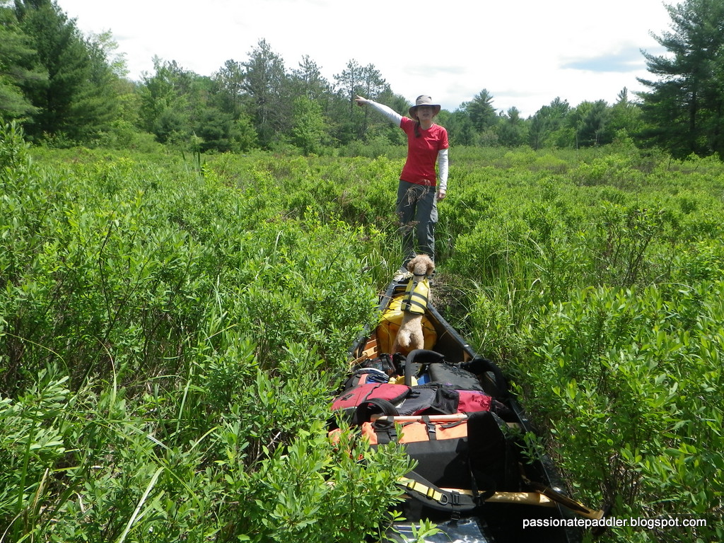
What a heartfelt moment, finding Mark's Lake.
Now someone push him in!!

These friends are not ordinary park trippers, they are Algonquinites. This is heady company with the likes of Jeff, who obviously knows the park inside and out, same for Mark Rubino, (markinthepark.com) who has practically seen most of Algonquin as an exclusive park tripper, Scott Rogers, (smedleyco.com) who is another park aficionado, and lastly, the Scarlett brothers, John and Mark, who have tripped in Algonquin for over 50 years! I myself have tripped many times in Algonquin and seen many areas through its varied seasons too, but I couldn't help feel slightly timid by these avid Algonquin trippers. 

Do you see a trail? - Rediscovering/reliving the old portage
from Barnet Depot to Alder Creek? Or was it?

I found out quickly that this group is a tough, gritty, well-greased tripping machine. They had recently completed the Meanest Link, a tough route through Algonquin Park honouring Bill Swift Sr., rediscovered new routes along forgotten portages/waterways, sought out lakes unconnected to typical routes and even created a new portage in the park! Did I mention they are not your typical Algonquin trippers? Unfortunately, they had lost their 'sixth', so was in search of a replacement. I was certainly flattered when I was asked to join this elite tight-knit team, but as you can see, the more I found out about them, it was plain intimidating. Labelling them Algonquinites in my opinion, was very fitting.

John enlightening us on the metal remains found near a cabin.
Being a blacksmith, he really knows his stuff!

It's always awkward joining a new group. I didn't really know anyone, including Jeff, whom I had just met. Plus, you always wonder if you will not only gel with the group, but be able to keep up to the group's level of intensity and style. Lastly, it's not like there was time for a meet and greet to get to know each other first, 
as the trip was starting in less than 2 weeks. I may have lots of tripping experience myself, but like the new kid on the block, you always wonder if you'll measure up to the group. It was a bit nerve racking, but I had to put it aside and focus on getting ready, as even my wife was on board with me going. She was totally fine with postponing our trip, as she figured it would be warmer by the time we went. (Nope!) Plus, she also thought I could benefit from some good old male bonding. (Like what was that's supposed to mean? Visions of Deliverance danced in my head!)

We ate well, and that is an understatement. Thank goodness
Algonquin has long portages to keep the beef off!

The start date of the trip was in constant flux due to many unforeseen factors. The later than expected ice out in the park, heavy rains that caused extensive flooding, and the resulting damage to many access roads. Because of the damage, the park was not issuing permits, so it became a frustrating waiting game. In the end, the trip date got moved to the beginning of May, including changes to the access point and the route itself. On May 4th, Jeff and I finally set off from Canoe Lake on an absolutely gorgeous day. (Anita was regretting her decision not to go, as the forecast for the week was +20C highs and sun all week!) The rest of the group was already at the park for a bi-annual gathering of avid Algonquin trippers, so I met them when we arrived a couple hours later. It was an ideal opportunity to socialize with people that shared the same interest, while eating and drinking the evening away. The weather was perfect for this, and soon enough, I was starting to feel comfortable being there. I was now more than ever, looking forward to the start of the actual trip the next day.

"The March" along old logging roads.
 Simply lead or follow along.

This year's trip was supposed to be an easy one, in comparison to previous years. That was the consensus I was getting from the group. It certainly wasn't a tough trip overall, but there was some days of note. For the most part, there was the typical amount of travel, mixed with portaging and sightseeing. Not the sightseeing where we are paddling around with cameras around our necks and posing in front of our canoes, but rather checking out old ruins and remnants of times gone past. I few of us had no clue that these ruins existed, despite passing familiar areas many times. We were entertained and educated by the Scarlett brothers, who were like historian/park guides that had the seen the park over the course of 5 decades and had witnessed many changes during that time. Did I mention they are 68 and 71? I stand correct by those numbers. Although, don't let those numbers fool you. They are just as fit and fast on the portage and water as the rest of us, and they probably carried a greater share of the weight! They are my new paddling paragons!

Remains of an Alligator on the shores of Burnroot Lake.
It's an incredible piece of Algonquin's 
logging history.

On the flip side, this group loves to go off trail, the beaten path, or where "no one has ever gone before". (Star Trek, move out of the way!) Now this is stuff I love. Bushwhacking, route finding, feelings of "Where are we?", or  "Are you sure this is the right way?!" It adds an exciting element to the rather mundane, paddle, portage, paddle, portage and then find camp. Sure, not everyone relishes this kind of stuff, but I certainly do. This group's mentality was right up my alley. On day four, we set off to primarily find a lake named after one of our members, Mark Rubino. Jeff had unofficially named this unknown/unnamed lake after him - Mark Lake. So the idea was to get Mark there, so that he could see it. (We were also hoping for him to experience it too by jumping in, but he chickened out after seeing that the water was dark and had a boggy bottom.) It was a combination of rock hopping, weaving through tight spruce, sinking in mats of bog, and stomping along old logging roads. We did make it, and Mark got his ceremonial picture beside 'his lake', but the tempo and pace of this 10 km excursion was aptly named "The March". You either followed, or got left behind. 

False alarm, not Alder Creek. At least we hoped not!
The search continues to find the end.

But that was only to prep us for the event the next day, which no one volunteered naming. Probably because they are descriptive terms not appropriate for this blog, as it really did make "The March" seem benign. The purpose of this exploratory excursion was to retrace an old portage that existed many years ago. This portage started from Barnet Depot and ended at Alder Creek, possibly to avoid the longish paddle around Burntroot Lake and a couple rapids to Longer Lake. It had obviously fallen out of use (I wonder why?) and was not maintained, so the question remained, was there enough to actually follow it? Most recently, Craig McDonald, an MNR employee who is well known for documenting old forgotten portages (nastawagn), marked a winter portage along this supposed route. But even then, there was questions on whether it was actually correct. Despite all this, blinded by this romantic notion of reliving an old forgotten portage, we set out with canoes atop our heads to find out. Sounds enticing, huh?

One of many stone chimneys left standing from
the remains of Camp Minnesing

Let me put it this way, if you know anything about winter portages, winter portage does not equal summer portage. I have 5 other witnesses who can testify to that fact. First of all, what was thought to be a 1200m carry, turned out to be almost double at 2 kilometers. Secondly, what started as a decent trail, eventually degraded to bushwhacking, maneuvering around fallen trees, splashing through marshes, forcing our way through alder thickets, and fighting our way out of boot sucking muck. It was a lot more than our group had expected. We decided early on to double portage, since we thought it prudent to scout the way through, as we had no idea of the trail conditions. However, it was soon clear to us, that despite the favourable start, we were pretty confident that we were not on an old portage, or for that matter, any trail at all. With all the time and energy spent to get to where we were, we had no choice but to move on. It wasn't easy, nor always enjoyable, or even healthy exposing our ears to those waxing eloquent monologues praising this unique trail, but we did it - four hours later. We were finally thrilled to see the snaky contours of Alder Creek as we emerged from a tangled mess of alders, but rather than give high fives, bear hugs and hoots of joy, everyone quickly and quietly jumped into the canoes and paddled away. I'll take it that the silence was a poignant way of saying, "Thank gawd it's over!"

The Scarlett brothers - the unrelenting paddling
-portaging team

Sure, we were probably the first in our present time (and possibly the last) to portage that very unportage-like trail, but that is the kind of things I enjoy. Discovering (for better or worse) new routes and pathways that take "the road less traveled". Maybe better phrased, the path that no one travels, but who's really 
paying attention. I really enjoyed the team's tenacity and perseverance to get through, helping each other and plodding on ahead, all the while scheming to hang Jeff by his underwear. (It was his idea, right?) Our group enjoyed some amazing weather, often had an abundance of great food, and experienced innumerable laughable moments. But, I will guarantee, any time we think about this trip, we will first fondly recall the portage that 'thou shalt not name', which has been indelibly imprinted (or scarred) into all collective grey matter.

The aftermath and carnage after the
 Barnet Depot portage!

Not all days were like this. There were many other memorable trip moments that didn't consist of pain. Overall, this canoe trip had a great mix of both. I have to thank Jeff for sticking his neck out and inviting me on this trip, as I thoroughly enjoyed time spent alongside everyone, whether relaxing on the Slingback, huffing along a portage, or huddled around the fire. It was awkward at first, not really knowing anyone, but by the end of the trip, I found out more than I really wanted to know about everyone. It really felt like a brotherhood, of shared hardships, laughs, and naphtha flavoured honey-mustard pretzels (you had to be there). It was not only a great trip, but an amazing experience with an amazing group of guys. As the trip neared its end, I wondered if I measured up and earned my keep as the 'sixth', as I was definitely interested in being part of next year's adventure. While paddling out under snow squalls and stinging ice pellets on the last day, I couldn't help but think about tripping with this group again. Nine days had quickly come and gone, and I was already feeling nostalgic. Yes, it was that good. So boys, when's the next trip?

Cheers to a great adventure!
tPP


Now there is six - Taken on our favourite
campsite on Burntroot Lake